By my calculations, over 65% percent of the nitrogen load in Ioway Creek on May 20 came from less than 1 percent of the land area in the watershed. We still don’t know why.
Revised May 31
Many people assume that fertilizer applied to turf grass is a major source of nitrogen and phosphorus pollution in Iowa. At a presentation to the Ames City Council, I was asked if a public awareness campaign aimed at lawn care professionals and homeowners would be an effective way to improve water quality in Ioway Creek. If we’re talking nitrogen, I don’t think so:
Because turfgrass covers a tiny proportion of the land in most Iowa watersheds, compared to cropland.
Because turfgrass is a perennial. Having something growing and taking up available nutrients year-round is the principle on which cover crops reduce nitrogen loss.
Because there was a study by Dr. Keith Schilling that found very low nutrient levels in shallow groundwater below six Iowa golf courses.
To that list, I can add local water quality monitoring including lab testing and sensor results from May. Nitrate in Ioway Creek and the South Skunk River were the highest we’ve seen for a few years, but while rural tributaries ranged from 12-20 mg/L of nitrate, College Creek (an urban watershed with plenty of turf grass) measured only 2.3 mg/L.
But even if turf grass in general isn’t a serious water quality problem, maybe some specific areas of turf grass are a problem. That’s what I thought after reviewing the data from our spring water quality snapshot on May 17. Volunteers found a big difference in nitrate levels between South Duff Ave and other sites in Ames. I wondered if it could be a mistake, so I went back out on May 20 with a bottle of test strips and a smartphone app that enables more precise measurements. It wasn’t a mistake (nitrate in Ioway Creek increased from 8.6 mg/L to 24 mg/L in two miles), but the results still weren’t making sense, so I kept testing and testing until I assembled the map below. By my calculations, 65% of the nitrate load in Ioway Creek that day was coming from just 1,500 acres!
The 1,500 acres includes Coldwater Golf Links, and the pattern looks like what I’d expect to see if the golf course was overapplying fertilizer. However, the golf course superintendent has informed me that fertilizer has not been applied since fall, and then only at a low rate. A volunteer tested two ponds on the course and found low levels of nitrate (1-2 mg/L).
The 1,500 acres include some developed areas north of creek drained by storm sewers, but I tested water trickling from two outfalls on May 20 and found very low nitrate levels: 0.5 mg/L and 3.1 mg/L.
The 1,500 acres acres also includes two construction sites: a flood mitigation project near South Duff Ave and an ISU recreation complex east of Jack Trice Stadium. The photo shows severe bank erosion where drainage from the ISU construction site enters the creek. An inspector with the Iowa DNR noted problems with erosion control earlier this spring on the South Duff project. However, if the nitrate spike were linked to erosion, I’d expect to see high phosphorus and low transparency.
Honestly, I’m not sure what’s going on here. It’s not a pattern we’ve seen in previous years.
When interpreting this kind of data, there is a risk of jumping to conclusions and unfairly pointing fingers. In my first draft of this article, I suggested that Coldwater Golf Course was the source of the nitrate and the bank erosion. That was premature.
However, there is also a risk that we will waste time and money on the wrong solutions or the wrong areas if we don’t test water or don’t follow where the data is pointing. It’s clear from this month’s data and many other rounds of testing that water quality impacts are not uniformly distributed across the landscape.
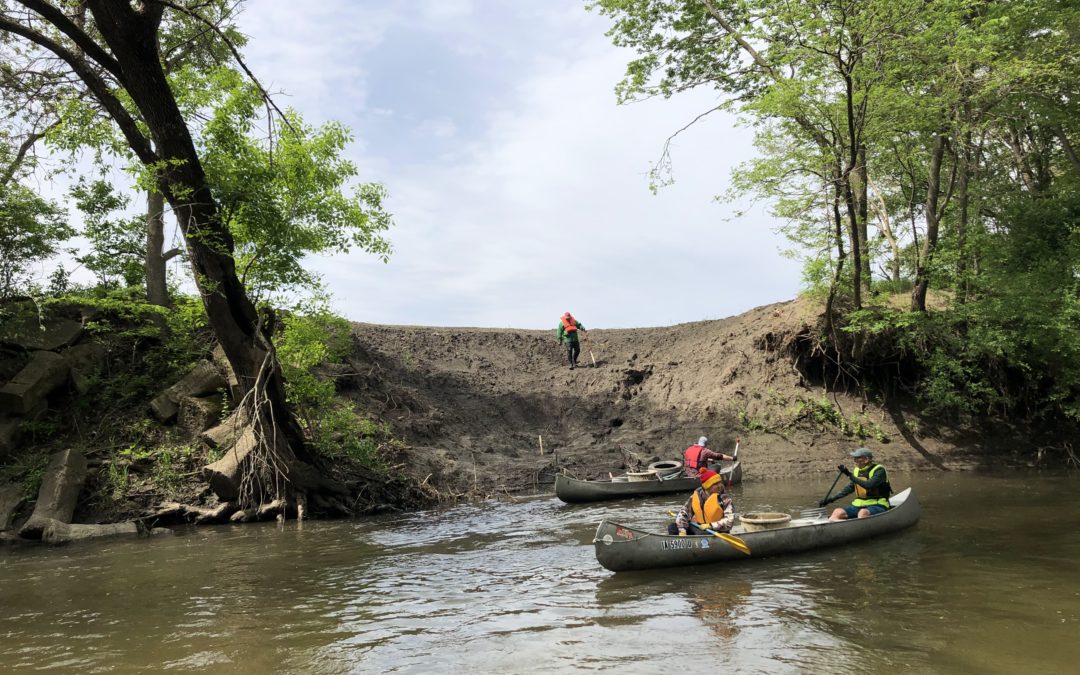
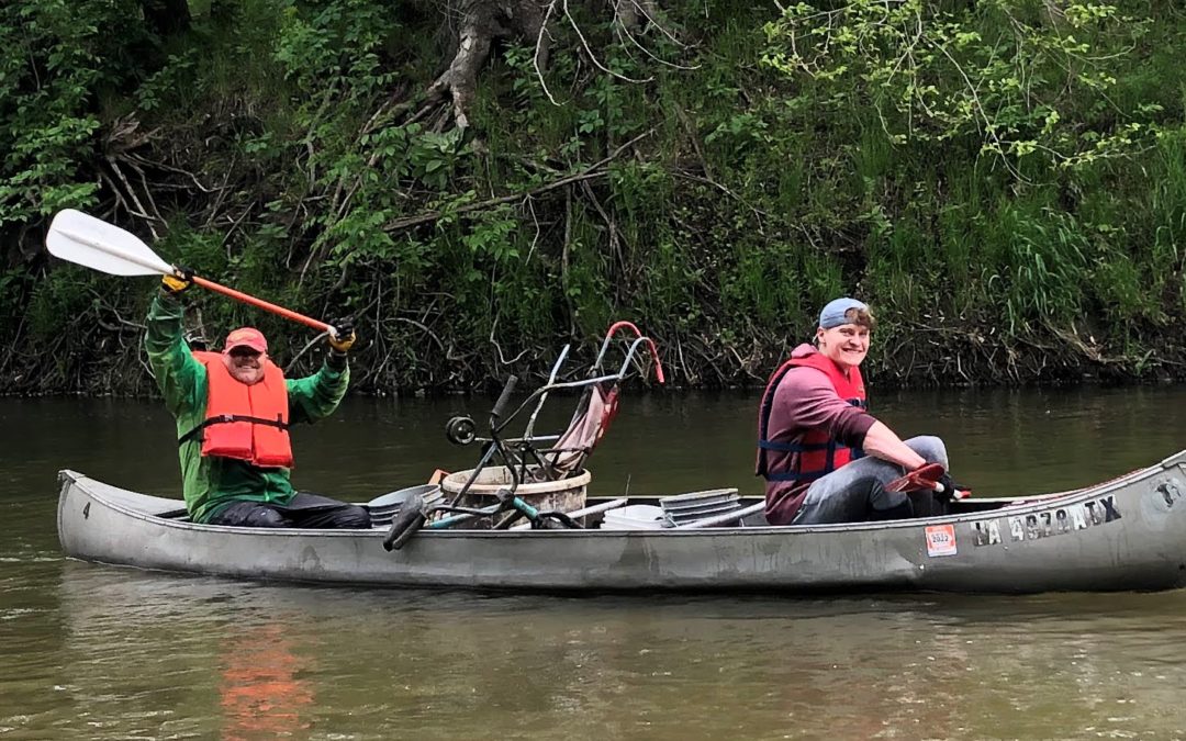
Ioway Creek recently got some love from the community. On Saturday, May 21, a group of seventeen volunteers (plus another four helping on land) loaded nine canoes with trash as we floated from Brookside Park down to S. 16th Street in Ames. We hauled out 14 tires and 1,560 pounds of other trash including 3 shopping carts, a tent, and two bicycles. Assembling the tools, canoes, food, and people was a collaborative effort involving Prairie Rivers of Iowa, the City of Ames, Story County Conservation, the Skunk River Paddlers, and the Outdoor Alliance of Story County. A few people got wet, everyone got dirty, my muscles are still sore, but we all had a good time on the river!
Citizen Science
On Tuesday May 17, fourteen volunteers tested water quality in Ioway Creek and its tributaries. This is the fifteenth Spring Watershed Snapshot, and the fourth that Prairie Rivers organized. Thanks to the Outdoor Alliance of Story County for help with supplies. This year, some volunteers were already doing regular monitoring of a site for Story County Conservation and adjusted this month’s schedule to coordinate, or picked up a few extra sites. If we include other watersheds and other days tested during the same week, the count is 22 volunteers (and also some Story County Conservation staff) and 47 sites in Story, Boone, and Hamilton counties.
We scheduled the event for a weekday this year to coincide with Polk County’s snapshot, so while the event was less social than it sometimes is (volunteers could pick up a kit any time on Tuesday and test their assigned sites alone or with a friend), they were monitoring as part of a big coordinated effort of the kind that we haven’t seen since before the IOWATER program was cancelled! In Polk County, 75 people covered 115 sites!
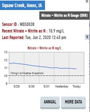
A table with our findings are shown below, and a map of the sites can be found here. On Tuesday, the water was clear and phosphorus was low at all our sites. Chloride was highest and nitrate lowest in creeks with more urban watersheds. Dissolved oxygen fell into the “fair” range at several sites in Hamilton County, as well as the south fork of Worrell Creek in Ames. Nitrate was 10 mg/L or higher at most sites, but reached 20 mg/L in the middle sections of Ioway Creek and several rural tributaries. I did some followup testing to make sense of the high nitrate levels at Duff Ave, more on that later.
Thanks to all the volunteers who spent some time in a creek last week!
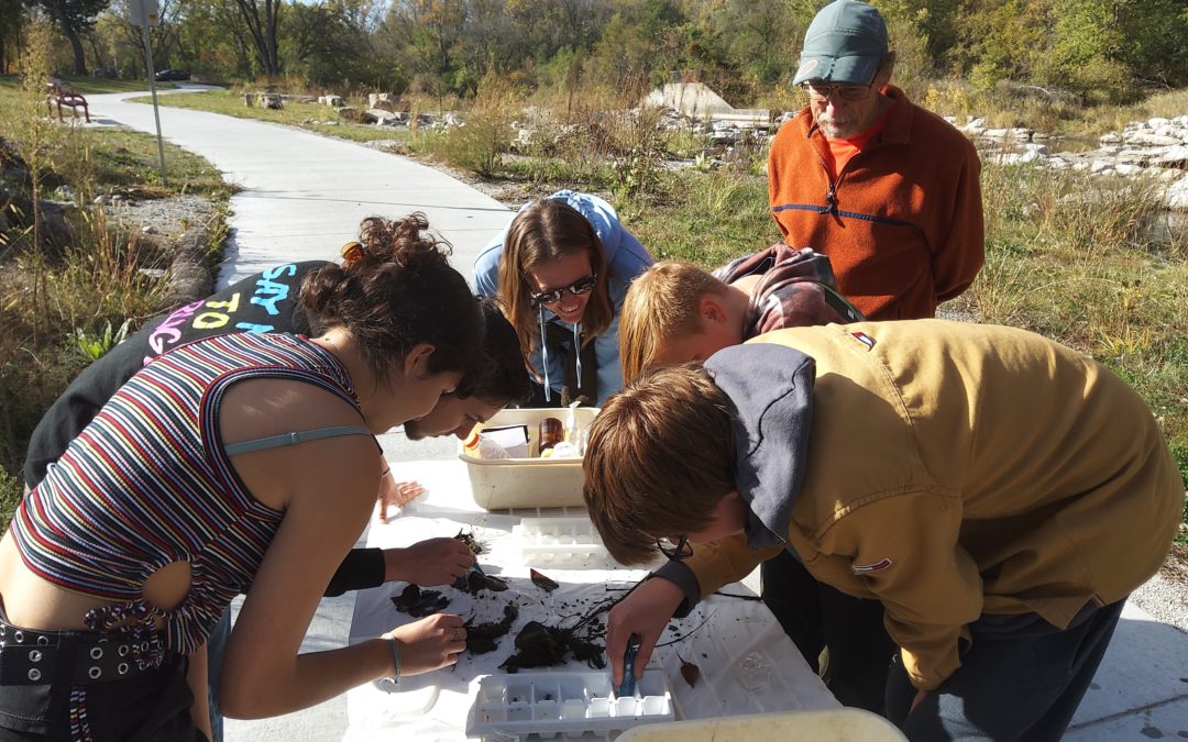
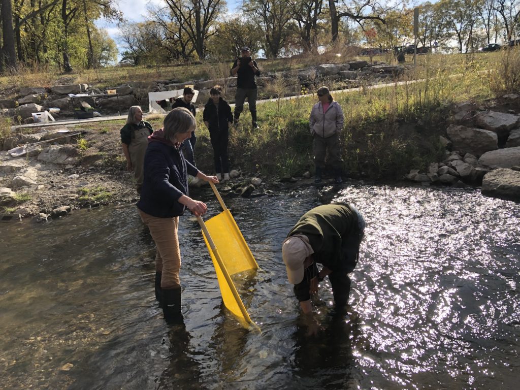
Thanks to the 15 volunteers who helped to catch benthic macroinvertebrates (bugs) and test water quality over the weekend!
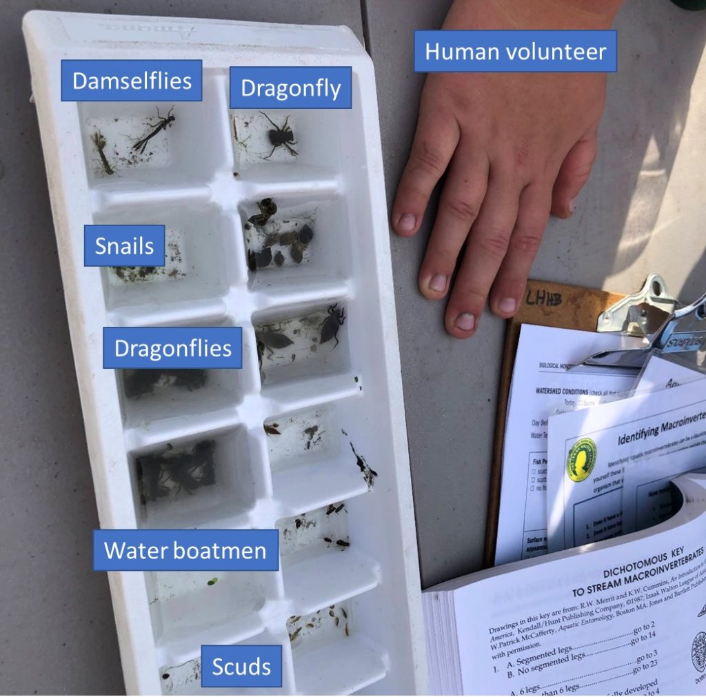
Volunteers capture benthic macroinvertebrates with a kick net, one of two methods we tried.
Ioway Creek “Snapshots” in May and October are a tradition going back to 2006. Volunteers test water quality at many locations on the same day to get a better picture of what’s going on in the watershed. Since the IOWATER program ended, Prairie Rivers of Iowa has gathered supplies and planned events to keep the tradition going, but this year there was just one little snag: there was barely any water in Ioway Creek or its tributaries!
For most of this fall, our usual gathering place at Brookside Park has looked more like the photo on the left.
Not a problem. The South Skunk River still had flowing water, and this was as good an opportunity as any to survey benthic macroinvertebrates (aquatic bugs), an indicator of water quality and habitat quality in rivers. We were helped in this task by Susan Heathcote, a trainer with the Izaak Walton League’s Save Our Streams program. If you’d like to become certified and missed out on this opportunity to complete the field portion of your training, keep an eye out for more training events with Susan in early spring.
Photo credit: Rick Dietz. Volunteers pick invertebrates off rocks and leaves and sort them in ice cube trays.
In addition to crawfish and dragonflies (always a hit with kids), we found a variety of smaller critters, including sensitive mayflies and stoneflies. Overall, the invertebrate community in the South Skunk River was “good.” In contrast, another stream we surveyed this week (West Indian Creek south of Nevada) had a “poor” score with mostly net-spinning caddisflies. We’ll discuss some possible reasons for this difference at a webinar on November 2nd.
Another option for when streams are dry is to spend some time interpreting the data we have. Following some water quality testing in the Skunk River, I gave a presentation to put those measurements into context. I think the data feels more relevant when you’re at the water’s edge and have just gone through the process of collecting it! If you prefer to do your learning somewhere warm and comfortable, we’ll be covering similar information at a webinar on November 2nd.
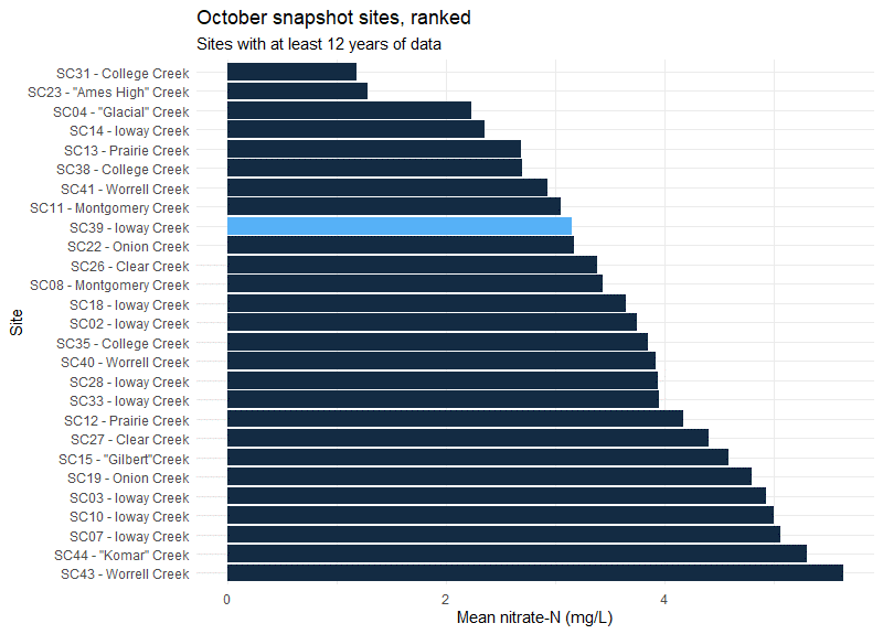
This fall, nitrate is zero in most streams that have any water, but over the past 15 years we’ve been able to see which tributaries have the highest and lowest levels.
Another hitch. Thunderstorms were forecast for Sunday! We changed the date to Saturday and are glad we did; the weather was beautiful. This also gave us the opportunity to set up equipment so we could capture water samples from the big rain on Sunday. Three volunteers helped me retrieve a dozen samples on Monday. The samples will be tested for E. coli bacteria and optical brighteners, which may help us find and fix septic and sewer leaks.
Ryan checks a crest stage recorder (a low tech tool for seeing how high the water got) and puts a fresh bottle in a storm sampler.
Many thanks to all who participated. We hope to see you at the next watershed snapshot in May, and hope the water levels will be back to normal!
Thirteen volunteers braved the cold on October 24 to test water quality in Squaw Creek, the South Skunk River, and their tributaries. For some, this was their 14th Fall Water Quality Snapshot. For others it was their first time doing stream monitoring. What we found defies easy categorization.
Update: The name “Squaw Creek” was officially changed to “Ioway Creek” in February of 2021, to be more respectful to native peoples. Over the next year, expect to see some changes to the names of the Squaw Creek Watershed Coalition and other groups that have formed to protect the creek, as well as maps and signs.
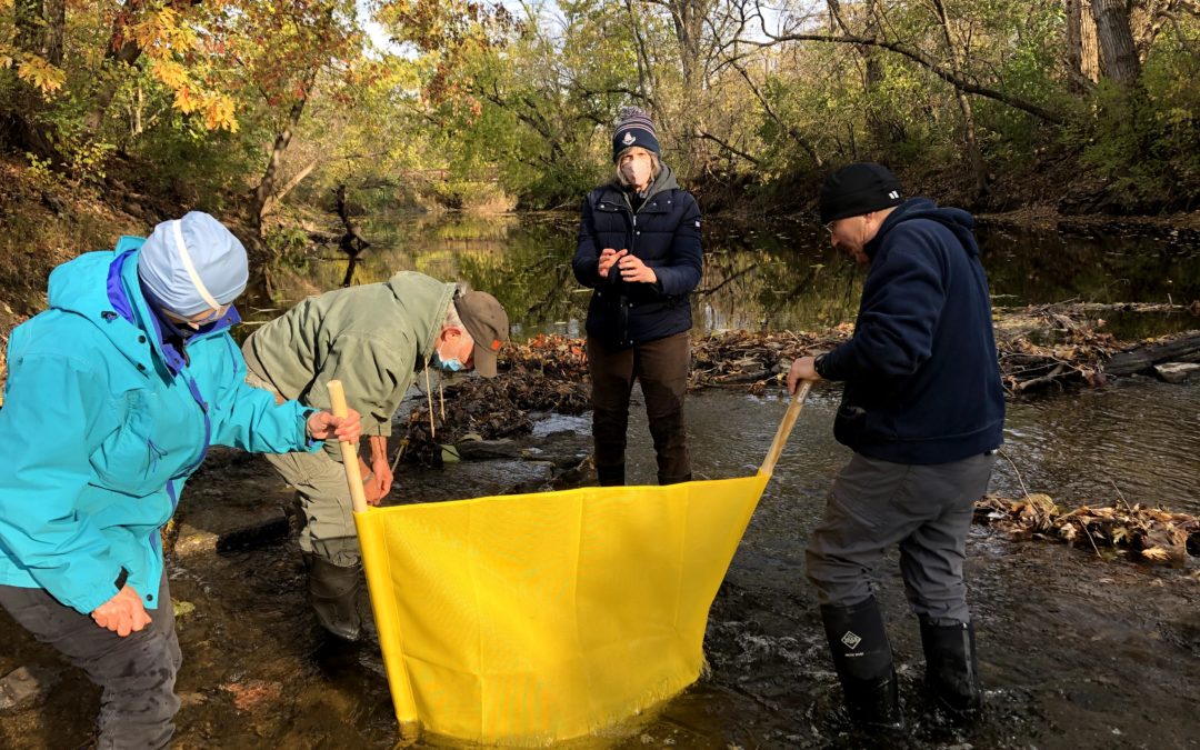
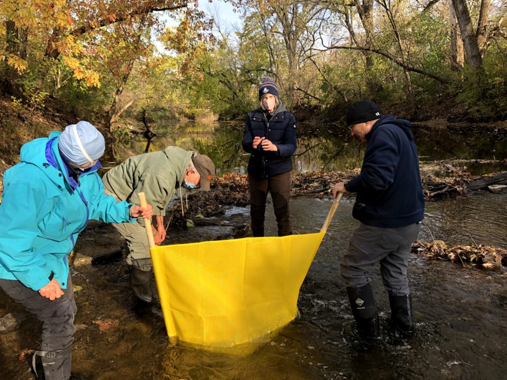
Volunteers Diane Birt, Paul Readhead, Liz Calhoun, and Rick Dietz take turns brushing off rocks to capture bugs in our net. The water was freezing!
By some indicators, water quality in Squaw Creek was good. Since I wasn’t sure how many creeks would be flowing when I planned this event, I added bug collection to the agenda to keep us busy. Excuse me. Benthic macroinvertebrate sampling. We were pleased to find tiny stoneflies and mayflies. They’re good fish food, ask any fly fisherman! Excuse me. An important part of the aquatic food web. These insects also act as a sort of canary in the coal mine. They need water with a lot of dissolved oxygen so will be rare or missing in streams with too much pollution, murky water, or not much in the way of habitat.
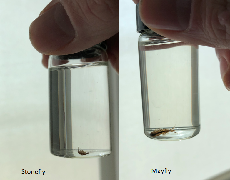
Fun fact: while the adult mayfly is notorious for living only 24 hours, the juvenile form (naiad) lives in the stream for several years. If you’re curious what adult mayflies and stoneflies look like, I found somephotos from our neighbors in Missouri.
By some indicators, water quality in Squaw Creek and it’s tributaries was bad. As in, there’s poop in the water. Excuse me, fecal indicator bacteria. This month, E. coli bacteria in Squaw Creek continued to exceed the primary contact recreation standard, and College Creek jumped above secondary contact standard. I wondered if this spike might be due to accumulated… debris… being washed out of the storm sewers and off the landscape by the 1.25 inch rain we received Thursday and Friday, but the lab samples were actually collected on Wednesday Oct 21, so I’m not sure. Anyway, covid-19 is not the only reason I bring hand sanitizer to these events!
By some indicators, water quality was unusually dry this fall. Nitrate was too low to detect at 13 of 16 sites we tested. Under wetter conditions, as we had this spring or last fall, nitrate in these same streams was higher and differences due to landuse or conservation practices in the watershed become more apparent.
Site
Watershed
Fall 2020
Spring 2020
Fall 2019
Squaw Creek @ Duff Ave
Rural and urban
0
10
5
Bluestem Creek @150th St
Rural
2
10
5
Glacial Creek @ U Ave
Rural (with a constructed wetland)
0
2
2
College Creek @ University
Urban
0
2
2
Nitrate-N concentrations, in mg/L
Water quality is rarely all good news or all bad news. Citizen science can us a more complete picture.
It turns out that stream monitoring is quite compatible with social distancing. 28 volunteers participated in the Squaw Creek Watershed Coalition’s 13th spring water quality snapshot on May 30 and 31. Together we tested water quality at 43 sites on Squaw Creek, its tributaries, and the South Skunk River! This time, Prairie Rivers of Iowa assembled the equipment, organized the event, and entered the data. We’re happy to support this dedicated group of citizen scientists in better understanding and drawing attention to our local rivers and creeks.
Update: The name “Squaw Creek” was officially changed to “Ioway Creek” in February of 2021, to be more respectful to native peoples. Over the next year, expect to see some changes to the name of the Coalition, as well as maps and signs.
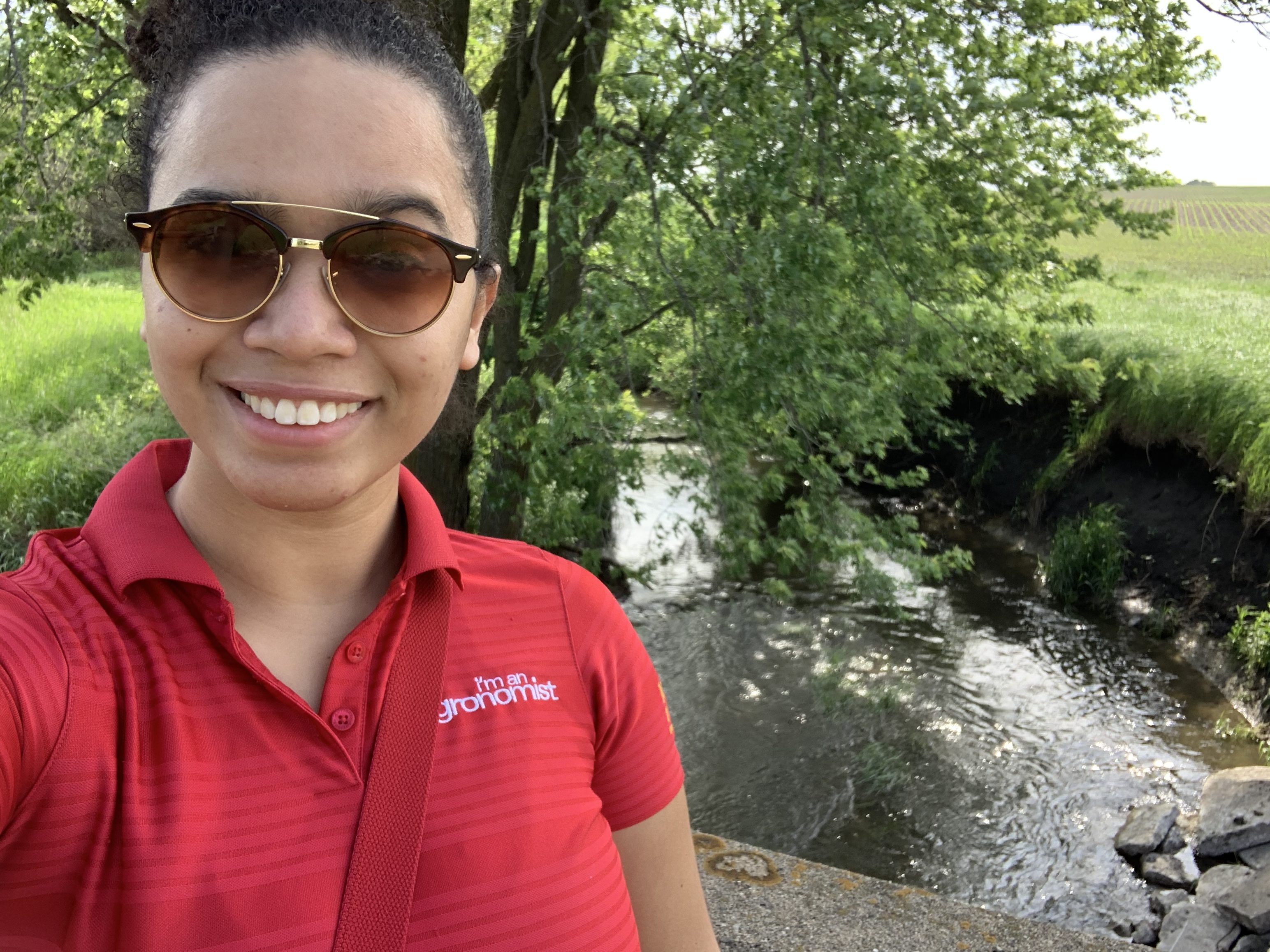
Here’s a few selfies taken by participants, a mix of long-term volunteers and new faces.
The Kopecky family by the South Skunk River
Jeff White at Gilbert Creek
Kelly Nascimento Thompson at Glacial Creek
Kurt Plagge and Mary Burnet at Onion Creek
As the name implies, this is a snapshot in time. The water quality on one sunny weekend in May is not necessarily representative of the month, let alone the year. As described here and here, water quality can change dramatically in response to a big rainstorm. But for this moment in time, testing many sites gives us a very detailed picture of the Squaw Creek watershed.
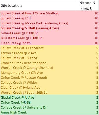
For example, during May 30 and 31, nitrate in Squaw Creek at Moore Park and other locations in Ames was quite high (11-12 mg/L) exceeding the drinking water standard (10 mg/L). Where is that nitrate coming from? All over its 147,000 acre watershed, but in some tributaries more than others, as you can see in the color-coded chart below. Nitrate was especially high in the upper reaches of Squaw Creek, Gilbert Creek and Clear Creek and especially low in Glacial Creek (which has a series of constructed wetlands and a lot of pasture) and College Creek (which has an urban watershed). The upstream, rural parts of College Creek and Clear Creek have higher nitrate, which appears to be diluted they move through town.
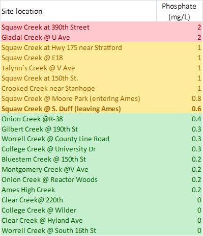
For phosphorus some of the patterns are flipped. Glacial Creek has especially high orthophosphate (the dissolved form of phosphorus) while Clear Creek is especially low.
There’s lots of interesting patterns to explore, and more data from this and previous snapshot events here. If you’re curious about water quality, subscribe to our blog, I’ll be continuing to interpret data from this and other sources.
Thanks to all our volunteers for collecting it!
Questions about stream monitoring, or observations from our volunteers? Post a comment.