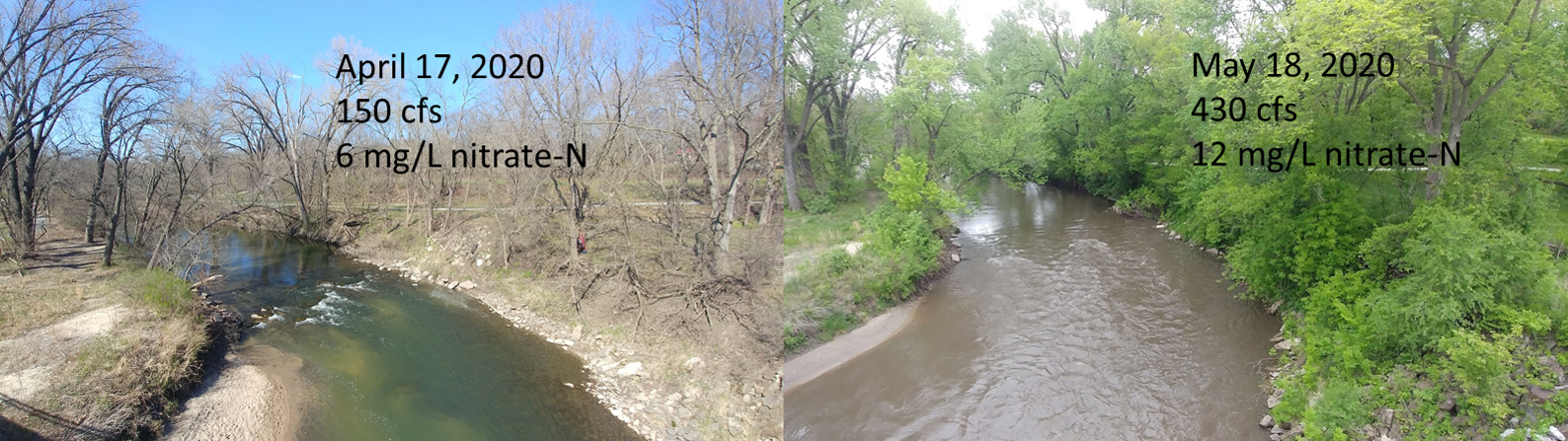
Last weekend’s rains (5-17-2020) provide a clear illustration of how water and nitrate make their way to Squaw Creek.
How water reaches Squaw Creek after a rain
It started raining late Saturday night and stopped around 3AM Sunday. The rain gage outside my house in Ames showed 0.9 inches. The water hitting my driveway and other paved surfaces in my neighborhood enters a storm sewer that goes directly to a tributary of Squaw Creek. (In newer neighborhoods, the water would be slowed down by a pond or detention basin). This runoff takes about an hour to make its way down Squaw Creek to the USGS stream gage at Lincoln Way. In response to urban runoff and the rain that fell directly on the channel, we can see a quick rise in the water level, and quick fall.
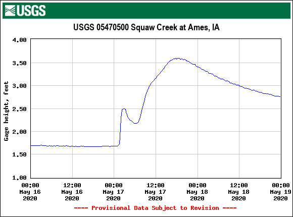
Over the next 15 hours, Squaw Creek rose another foot as it was joined by water that fell as far away as Stratford and Stanhope. Other than urban areas, we probably didn’t see much runoff from the storm, which was relatively gentle and fell on soils that weren’t particularly steep or waterlogged. The fall in water level Sunday afternoon and Monday was more gradual, reflecting the release of water from drain tiles and groundwater.
How nitrate reaches Squaw Creek after a rain
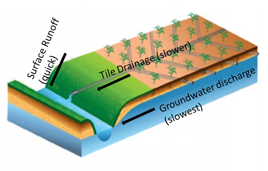
It’s well-known that tiles and ditches provide a direct pathway for nitrogen to leak out of the soil in corn and soybean fields. Think of cover crops as a way to plug the leak, and bioreactors, saturated buffers, and wetlands as a bucket placed underneath. You can watch the leak from last weeks’ storm with IIHR’s nitrate sensors. This graph is from a sensor installed in Squaw Creek in Moore Park, where it enters Ames. (The colors are the reverse of what you’d expect–brown is streamflow, blue is nitrate).
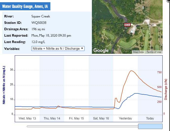
The nitrate concentration in Squaw Creek fell from 5 to 4 mg/L overnight, diluted by direct precipitation and urban runoff, and then rose to 14 mg/L as water from drainage tiles made its way downstream. As tile flow tapers off, nitrate concentrations gradually fall toward the lower levels seen in groundwater.
Nitrate drops as you move downstream
In Hardin County, there’s a nice set of three sensors that clearly showed what happens as water moves downstream during this storm. Not every stream demonstrates this behavior, but many do.

At the tile outlet, nitrate levels are highest to begin with (10.9 mg/L) and show the sharpest increase, spiking to 18.3 mg/L by 5AM after some initial dilution. Since the water takes some time to reach the next downstream sensor, Tipton Creek near Hubbard, the peak doesn’t happen until 8 PM, rising from 8.6 mg/L to 17.1 mg/L. Further downstream in the South Fork of the Iowa River, near New Providence, water is reaching the sensor from several tributaries, smoothing out some of the changes. Nitrate rises from 4.5 mg/L Saturday night to a peak of 16.2 on Monday morning at 11:00.
There are several reasons why nitrate tends to decline as you move downstream. First, tile systems drain mostly agricultural land, while a larger stream will also drain some field margins, pasture, and woodland. Second, nitrate is removed from the water by algae, plants, and microbes. Waterlogged organic matter, whether in a low spot in a field, a wetland, a stream bottom, or a woodchip bioreactor, is good habitat for denitrifying bacteria. Third, many Iowa streams flow from northern Iowa southeast to the Mississippi River, or southwest to the Missouri River, and as you get into southern Iowa, the land becomes hillier, tile drainage becomes less frequent, and pasture more common.
Tile drained fields lose a lot of nitrogen in spring. That’s not news to anyone, but hopefully this helps you visualize and understand the process.
Update, 5/29/2020: We had even bigger rains the following week, but spread over several days, so the pattern was less clear. We’re still seeing nitrate concentrations >10 mg/L in the rivers, and >15 mg/L at tile outlets.