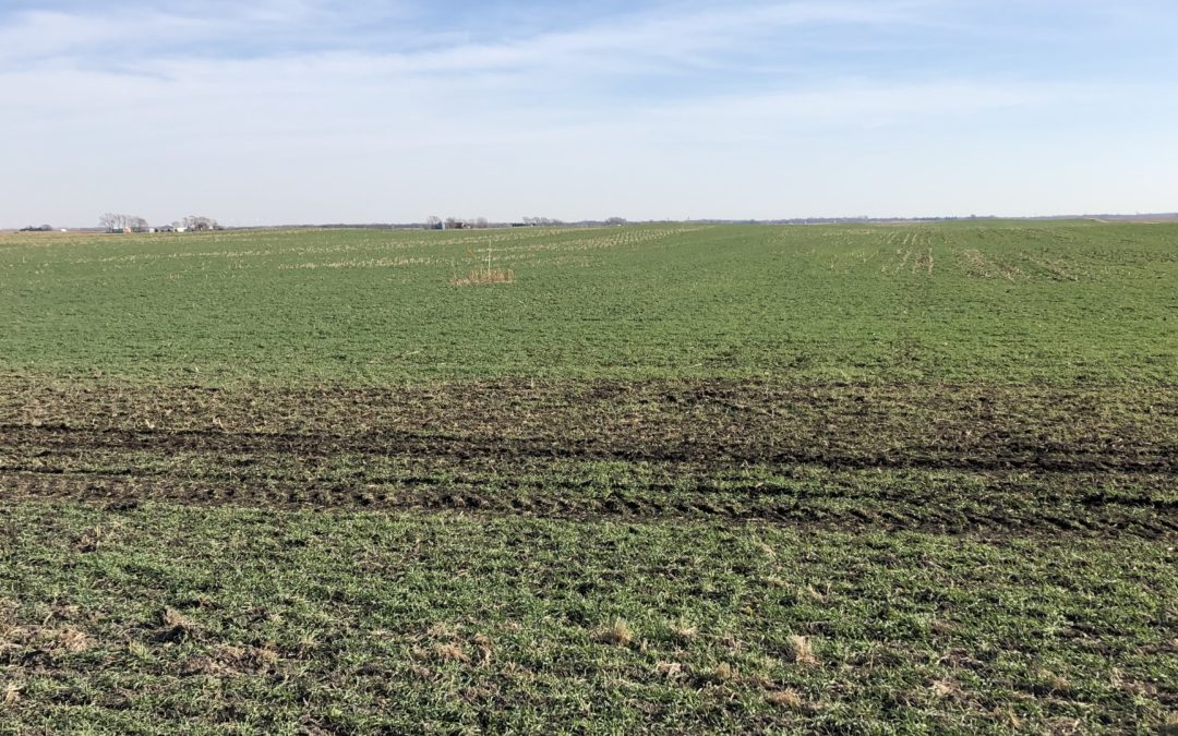
Nice looking rye cover crop near Nevada, IA November 2020
A big thank you to farmers who planted cover crops after this challenging year. Cover crops will hold soil and nutrients in place through the winter and early spring. That could be especially important this year.
After a drought, nitrogen that might normally have been taken up by a high-yielding crop or flushed away by rainfall remains in the soil. That leftover nitrogen could be available for next year’s crop, but only if:
A) we have a dry spring, or
B) farmers have made use of practices like cover crops or nitrification inhibitors that prevent nitrogen losses during the fallow season.
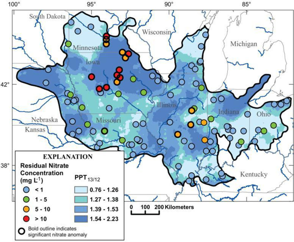
A wet year in 2013 following a dry year in 2012 (dark blue) caused nitrate concentrations in many central iowa streams to jump as much as 10 mg/L higher than usual (red). Figure from Van Metre et al. 2008
A drought in 2012 following by a wet spring in 2013 led to nitrate concentrations in excess of 20 mg/L in many rivers in Central Iowa. If we have a wet spring in 2021, we could see this happen again. As one scientific paper put it, “weather whiplash drives deterioration of water quality.”
“Weather whiplash” can also help explain the long-term trends I’ve been seeing in the South Skunk River and its tributaries: a decline in nitrate concentrations from 2005-2012, a big jump in 2013, and another decline over the past 7 years. I’ll walk you through my analysis.
Explaining nitrate concentrations in the South Skunk River
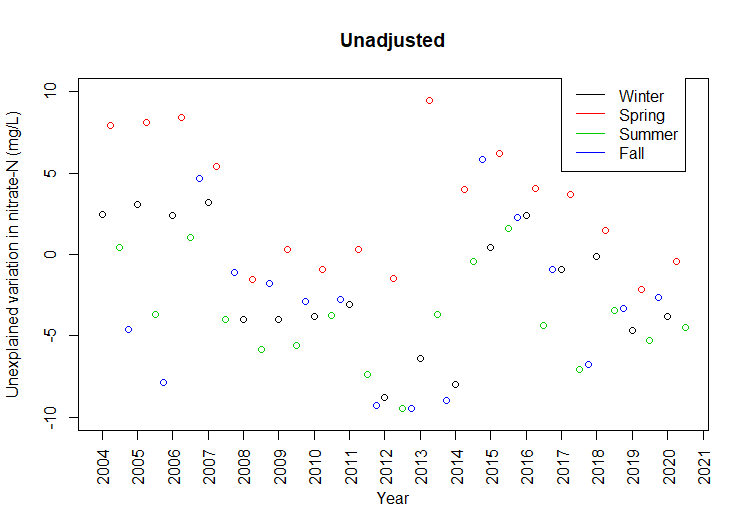
Technical details, feel free to skip: This data was collected by the City of Ames just upstream of wastewater treatment plant. The City has monitored the South Skunk River above and below its wastewater treatment plant almost every week since 2003! Flow is measured continuously at a few miles upstream USGS gage near S. 16th St. I’ve summarized nitrate concentrations and streamflow by season (Jan-Mar, Apr-Jun, Jul-Sep, Oct-Dec). At each step of the way, I apply a linear regression equation and graph the model residuals. Taken together, these three factors explain 59% of the variation. The effects of “weather whiplash” may extend beyond one year, since nitrate from some parts of the field may travel more slowly to streams via groundwater.
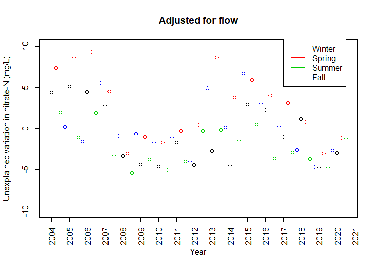
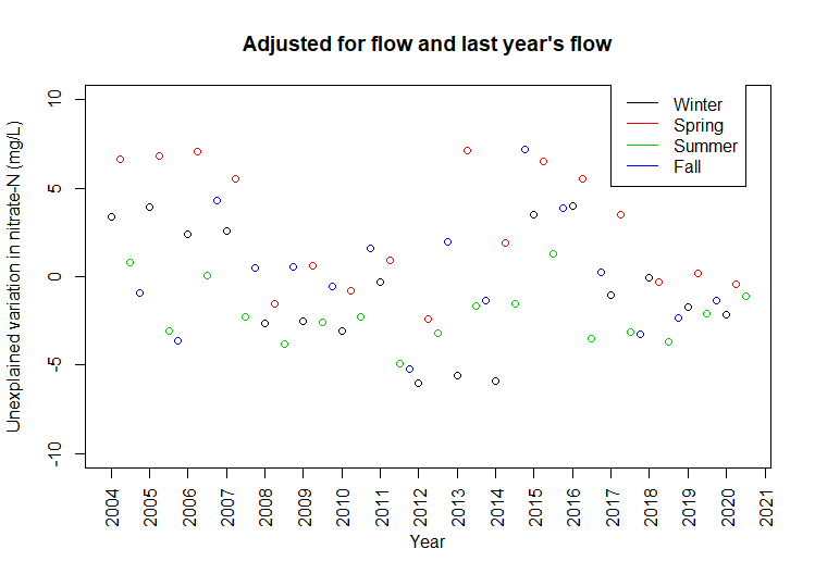
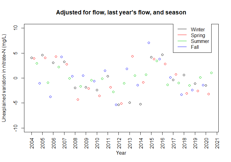
In a given quarter, nitrate concentrations in the South Skunk can be up to 10 mg/L higher than the long-term average, or as much as 10 mg/L lower. The following graphs show how much variation is left to explain after correcting for current weather, last year’s weather, and season.
Nitrate in the South Skunk is again declining after a sudden increase in 2013.Low-flow conditions in 2011-2013 explain unusually low nitrate concentrations.
Wet springs following dry years explain unusually high nitrate concentrations.Seasonal patterns explain some of the remaining variation.
The lowest nitrate concentrations can be explained by streamflow: when the weather is dry and tiles aren’t flowing, nitrate levels in rivers taper off to the background levels seen in groundwater.
The highest nitrate concentrations can be explained by weather over the previous 12 months: a wet period following a dry period will flush out nitrate that’s accumulated in the soil.
After that, there’s still a seasonal pattern independent of rainfall: nitrogen is most susceptible to loss in spring when soils are bare and microbial activity picks up (April-June) and least susceptible when the maturing crop is using up the available nitrogen (July-Sept).
Can some of the remaining pattern be explained by greater adoption of conservation practices in the watershed in the past 5 years? We hope so, but let’s see what happens next spring!
This is a good time of year to enjoy the South Skunk River Water Trail and other local waterways!
I joined the Skunk River Paddlers this weekend, paddling my kayak from Anderson Access to West Petersen Park. While the main purpose of the outing was fun, we also hauled out some tires, cleared some smaller obstructions, and made note larger logjams for followup. The water was chilly but the air was pleasant. Bluebells were blooming on the bank and we found live mussels in the water (this one is a plain pocketbook).
While central Iowa has been spared the extreme flooding that has devastated communities on the Missouri and Mississippi, it’s been a wet fall and a wet spring, and we saw the evidence of that on the river. Bark had been scraped off trees by ice flows, lots of bank slumping, and lots of exposed roots.
The roots here illustrate the value of riparian buffers. A good stand of perennial vegetation can hold a bank together and keep phosphorus out of the Gulf.
If you’re interested in establishing a riparian buffer on your farm, especially if you live near West Indian Creek, Long Dick Creek, Clear Creek, or Worrell Creek give Prairie Rivers of Iowa a call!
An update on our watershed planning efforts is long overdue. Our NRCS Conservation Innovation Grant for the “Keigley” watershed project wrapped up in September of 2018. Here’s some of the highlights from 2017-2018 and what we’ll be doing next.
A change in focus: No more need to explain that by “Keigley Branch Watershed” we really mean “part of the South Skunk River.” In the future, we’ll be working with the entire 200,556-acre watershed that drains to the South Skunk River above the confluence with Squaw Creek in Ames. On paper, a single ten-digit hydrologic unit (HUC10) seemed like a more manageable project, but as we talked with the public it became clear that watershed plans and partnerships would be more effective if the river’s headwaters in Hamilton County were included sooner rather than later.
Hamilton County Soil & Water Conservation District
City of Ames
City of Story City
City of Roland
City of Randall
We hope more jurisdictions will join as the partnership takes shape. Good communication between the cities, counties, and conservation districts in a watershed leads to more and better projects that improve water quality and soil health.
Great public input: 80 people—56 residents, 15 high school students, and 9 ISU students—attended our public workshops. The goals and implementation strategies they suggested will provide a great starting point for the WMA to develop an actionable plan for conservation in the Headwaters of the South Skunk River watershed.
An interactive map of conservation opportunities: Between this project and Story County’s assessment of its watersheds, we have identified suitable spots for bioreactors, grassed waterways, constructed wetlands and other agricultural conservation practices across 728,144 acres! Check out our interactive map to get ideas for conservation practices that might work on your farm or in your watershed, along with an explanation of each practice.
Winter is a busy season for grant-writing. We are currently looking for funding to provide education and technical assistance to farmers and landowners in this watershed, to build partnerships with more groups in Hamilton County, to fill in missing information identified during the planning process, and to support the new WMA in completing a plan for the Headwaters of the South Skunk River watershed. This is just the beginning!