Heading west on the Lincoln Highway, we come to our next Carnegie Library in DeWitt, Iowa. DeWitt had a public library long before it had a Carnegie Library. In 1897, a large group of citizens created the DeWitt Library Association by selling stocks. Stockholders gave $1 every 6 months for 5 years to have access to the library. Non-stockholders could also obtain a library card by paying a fee of $1 every year. The library contained 800 volumes.
By 1901, the citizens, as well as electors, petitioned for the library to be a Free Public Library funded and maintained through taxes. On March 25th of that year, during a regular municipal election, a majority vote was reached in favor of the Free Library. In January of 1902, the stockholders voted to turn the library over, and on April 2nd, the deed was transferred to the city. On April 7th, the Free DeWitt Public Library was opened to the public in a rented building on Main Street.
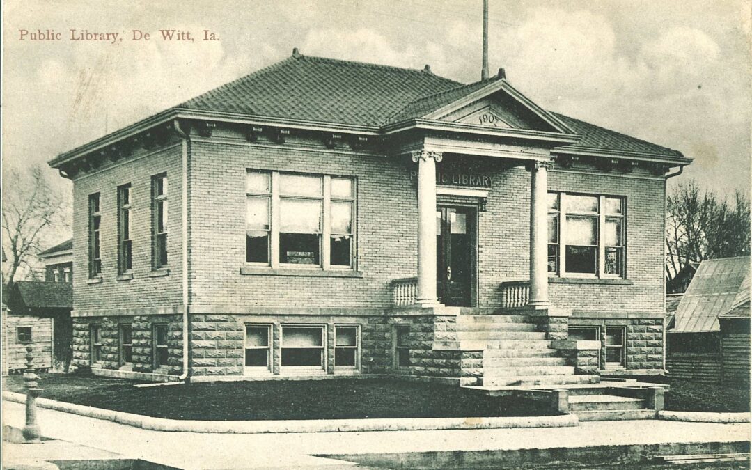
It wasn’t until 1906 that the DeWitt Public Library Board of Trustees began discussing the possibility of a Carnegie Grant, but with the growth of the library, a new space was needed. By April 8th, 1907, a Carnegie Grant was offered with the usual requirements of the city, which many were already met; a location was all that was needed. The corner of what is now 6th Ave and 9th St. was chosen.
The original grant offer was for $5,600, and an additional grant of $1,516 to complete the build. The architect of the Neoclassical design is unknown, and the contractor was Large Brothers from DeWitt. The opening date was June 1, 1908, and by 1909, the collection had grown to 1,774 books serving not just DeWitt but also surrounding communities and even troops during WW1 and WW2.
A remodel was done in 1962 to lighten the dark interior and add shelving and desks, but by the 1980s, the Board began looking for a new location as they had outgrown the Carnegie Building. After raising the needed funds and receiving large donations, the Frances Banta Waggoner Library opened its doors across from Lincoln Park. With 7,500 square feet of space, the library could now offer meeting areas and computer stations. The staff and volunteers moved the 15,000 volumes of books to the new location.
For a time, the town’s City Hall was located in the Carnegie Building until it outgrew the space. Then, a couple converted the building into a family home. In March of 2016, Jon and Lindsay Thiel bought the building and converted it into an event space.
This time is significant as they restored the original hardwood floors and wood trim around the doorways, converted the old wooden doors into the bar, and added handicap accessibility.
They chose to name the business ‘The Old Library’ as the building was already affectionately referred to by the town. The lower level was then rented to Soul Sisters Boutique (still in business but at a different location).
The Old Library event center and bar was successful, still, the busy life of the Thiels led them to sell the business to Beth and Martin Lanhart in February 2018. The Lanharts remodeled the building once again to expand the business with a kitchen and restaurant, which still operates today!
The Old Library is a family-run restaurant that takes pride in crafting every dish with care. They are open Wed-Sat 5 pm-9 pm.
Meanwhile, the Frances Banta Waggoner Community Library was outgrowing its space once again. In 2019, the library received a Community Attraction and Tourism grant from the Iowa Economic Development Authority and expanded the library to fill the entire block of 5th Ave between 9th and 10th Streets. They also moved the front door to 5th Ave and decided to rename the library, the DeWitt Community Library, with the after-hours entrance being the Frances Banta Waggoner Community Library Entrance on 10th St. The new library space provides space for several private study rooms, as well as separated age-appropriate reading and activity spaces, classrooms, and community art space.
The community of DeWitt and the surrounding areas has a deep history in the value of education available to all, and it shows through their story.
In October of this year, Carnegie Libraries across the nation received an email alerting them to a gift no one was expecting. The Carnegie Corporation of New York (originally the Carnegie Foundation) stated on their website that Carnegie Libraries will each receive a $10,000 gift to commemorate the 250th anniversary of the signing of the Declaration of Independence. To qualify, libraries must have been originally funded by the Andrew Carnegie Foundation, remain operational, and acknowledge their Carnegie heritage. Cedar Rapids is an example. Cedar Rapids, for example, continues to honor its Carnegie connection, even though its Carnegie building is now a part of the Cedar Rapids Museum of Art. Gift recipients may use the funds however they wish to celebrate the 250th anniversary, thereby advancing their mission and benefiting their communities (Carnegie C of NY press release).
Between 1892 and 1917, fifteen Public Carnegie Libraries and one Academic Carnegie Library were located and built along the Lincoln Highway in Iowa. Many of these libraries were built in towns along the Lincoln Highway because they linked communities and gave Carnegie’s libraries even greater visibility and accessibility. In western Iowa, a line can connect the dots where a Carnegie Library can be found in Denison, in Dunlap, in Logan, in Woodbine, and in Missouri Valley.
In exchange for the free grant to build a library, the communities receiving the grants needed to obtain property, city support, an architect, a builder, and the books to fill their library. It was often women’s groups or single librarians who applied for the grants and who were tasked with getting city support for the endeavor.
Of Iowa’s 108 Carnegie libraries, 52 are still in use as libraries today, 46 exist but are no longer libraries and 10 no longer exist. Of the Lincoln Highway’s 16 libraries built, 7 are still used as libraries: Clinton Public Library, Ames Public Library, Jefferson Iowa Public Library, Norelius Public Library (Denison), Logan Public Library, Woodbine Carnegie Library, and Missouri Valley Public Library.
All Lincoln Highway Carnegie buildings still exist although the remaining 9 outgrew their buildings and built new libraries as opposed to building additions. Carroll, Cedar Rapids, and Council Bluffs are museums, Marion and Dunlap are used by churches, DeWitt is a restaurant (The Old Library), Marshalltown is a government building, Tama is privately owned, and Cornell in Mount Vernon is the Norton Geology Center and Anderson Museum (academic and public shared). Iowa Valley Carnegie libraries include Marengo and Traer (audio tour); both remain operational as libraries.
Byway Carnegie Libraries who have announced on Facebook that they are accepting the gift include Traer (Iowa Valley), Clinton, Carroll, Logan, and Woodbine. The libraries are asking their patrons to share stories about their library and submit photos for possible inclusion on carnegielibraries.org. The site is part of Carnegie Libraries Across America, a resource that enables visitors to learn about each building. Iowa has a similar program, Carnegie Libraries in Iowa Project. Reach out to your local library to find out how to submit your stories.
For more information on Andrew Carnegie’s library legacy, check out a timeline and a video posted by the Carnegie Corporation of New York. Stay informed by signing up for the foundation’s Unstacked newsletter.
Wherever you are on the Lincoln Highway Heritage Byway, you are near an Andrew Carnegie historic library building. With Iowa’s library open access program, you can check out more than just the history. Follow me on the byway as we explore the 16 Carnegie Libraries of the Iowa Lincoln Highway Heritage Byway and the two along the Iowa Valley Scenic Byway.
Hello byway travelers! You may be wondering where we have been (unless of course, you follow the “Where Was I on the byway” series on social media).
We have been very busy in the byway department. Our former Lincoln Highway Coordinator and now Special Projects Consultant, Shellie Orngard, finished a two-year study on historical structures in the Lincoln Highway Corridor.
“Many historic properties have been lost over the years, and it is critical that this work be undertaken to avoid losing more… Surveys are a point-in-time snapshot of properties and to ascertain their preservation needs. The end product provides information gathered and includes recommendations for preservation.”
We were fortunate to have a student working with us the past several months and we kicked out some “to do” list items.Our student spent time editing a new series, “Tales on the byway.”
This is an oral/video history project we are experimenting with to record conversations with people who have lived and worked along the Lincoln Highway Corridor. The video was recorded for the Colo Historical Association and will be played at the Reed Station Museum during open hours.
The Iowa Valley Scenic Byway Audio Tour App is something we have been spending time getting up and going, and learning about future capabilities. We needed to change the name and online location of the App so that we can expand with future tours featuring recreation areas and the Lincoln Highway once funding can be secured. The new location is: https://seeyouonthebyway.stqry.app.
Be sure to use the share icon (square with an arrow) to choose “save site to home screen.” We continue to make changes and updates to the app as we gather updated information, photos, and links. A great new “Quiz” section will be added in the coming months.
“Where Was I on the byway” continues to be the Lincoln Highway Byway theme for Wednesdays on social media and we have added a series to the Iowa Valley Scenic Byway called, “Where Was I on the App”. This series encourage exploration of the App, the audio tour, and ultimately to visit the communities.
We made much-needed route updates in our source map for the Lincoln Highway Heritage Byway. Recently, the Iowa Department of Transportation completed the Hwy 30 four-lane from Lisbon to Ogden. With this construction, there were a few changes with how the Lincoln Highway enters and exits the four-lane. We are patiently awaiting new signs to complete the sign updates in Lisbon, Chelsea, and the Ralston Corners area where the route was incorrectly signed several years ago. Continue to reference the Lincoln Highway Map until we can update these sign inconsistencies.
Speaking of road construction (after-all it is spring in Iowa), we have just linked a map to our Lincoln Highway Heritage Byway website that has most of the summer/fall road construction locations marked along our updated route. We have been experimenting with the My Google Maps and trying to see how we can add information with a limited number of layers, so note that the layers in this map are still a work in-progress.
Those are the highlights of what the byway team has been up to since January. We continue to be involved with the Reed-Niland Corner’s progression with developing preservation guidelines and the development of the Reed-Niland Corner non-profit. We are working with the City of Tama regarding the Lincoln Highway Bridge. An alternate vehicular route has been constructed around the bridge. We need an inspection to move forward.
June will keep us busy again with the Preserve Iowa Summit, where Shellie and Jeanie will be a part of the round-table presentations and discussion on June 7th.
We will be hosting a viewing of the Iowa PBS Road Trip Iowa Lincoln Highway episodes on June 19th at the Clinton Area Showboat Theatre with special guest, Kelsey Kramer. Kelsey is the producer of the eastern Iowa episodes. This event is FREE to attend and is open to the public. Shows begin at 9:30 with a discussion with Kelsey to follow.
Also during the tour, the Iowa Lincoln Highway Association President, Mary Preston, will be at the Cedar Rapids evening Tour stop and Joyce Ausberger is hosting lunch at the Lincoln Highway Museum on June 21st. All are welcome to travel along; only those on the tour can attend meals.
And then it is off to Ogallala for the Lincoln Highway Association Conference, where we will be taking the traveling exhibit, “Promise Road, How the Lincoln Highway Changed America.”– There is still time to register!
In November, the EPA partially approved Iowa’s 2024 Impaired Waters List, adding six additional river segments where drinking water use is impaired by high nitrate levels. I think EPA was right to do this, but I have some concerns. This is the letter I submitted during the public comment period.
Dear Water Division Staff,
I agree with the EPA’s decision to add seven river segments to Iowa’s impaired waters list. I hope that this change will lead to greater transparency about how nitrate pollution of surface waters affects the cost and safety of drinking water, but am concerned there will be unintended consequences.
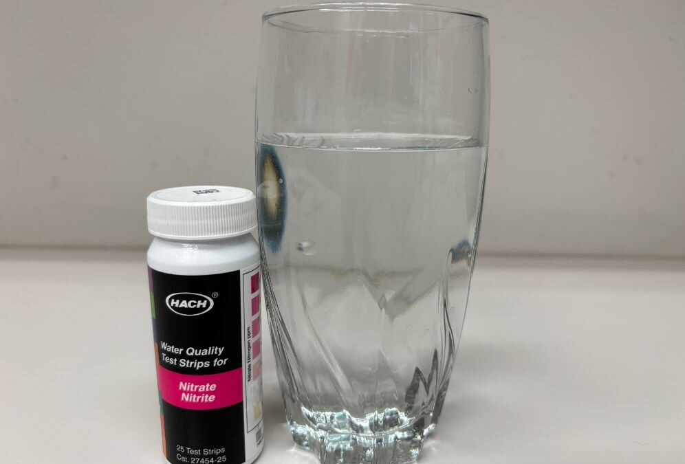
Iowa’s Credible Data Law has sometimes been a convenient excuse to assess fewer waters, and thereby discover fewer problems. However, that doesn’t seem to be the issue here. Each of the water bodies on this list had at least one “credible” nitrate sample exceeding the 10 mg/L drinking water standard during the three year assessment period.
Raccoon River near Des Moines: 38 of 755 samples collected by Des Moines Water Works exceeded 10 mg/L
Cedar River near Cedar Rapids: 1 of 36 samples collected by the USGS, and 7 of 151 samples collected by Cedar Rapids Water Works
As I understand it, the issue is the threshold for impairment. Since fewer than 10% of the samples (accounting for some statistical correction factor) exceeded 10 mg/L, IDNR says these sites meet the standard. EPA says they do not.
The Iowa DNR’s position is not defensible. In the draft 2024 assessment, Raccoon River near Des Moines was shown as fully supporting its designated use for drinking water because
A) Nitrate in the Raccoon River exceeded 10 mg/L nitrate less than 10% of the time during the 2020-2022 assessment period
B) Nitrate in finished drinking water at the Des Moines Waterworks never exceeded 10 mg/L.
This makes no sense. Even one sample exceeding the Maximum Contaminant Level for nitrate would constitute a violation of the Safe Drinking Water Act, requiring public notice. To avoid this, the Des Moines Waterworks had to run its nitrate removal facility for weeks in 2022 at a cost of $10,000 a day, as well as blending water from other sources and asking residents to reduce water use. Clearly, poor water quality is limiting that beneficial use of the river water!
However, the South Skunk River no longer supplies drinking water to the City of Oskaloosa. The City now gets its water from an alluvial aquifer, and is able to achieve low levels of nitrate in finished water (1.17 mg/L, in the latest Consumer Confidence report) without expensive treatment. I understand that the Clean Water Act does not allow designated uses to be removed if restoring them is still achievable. However, I hope that in prioritizing and writing TMDLs we can be cognizant of facts on the ground. In the unlikely event that a TMDL for the Skunk Skunk River is written and it leads to stricter effluent limits for upstream point sources, we might be imposing real costs on Ames, Story City, and Nevada without achieving real benefits for Oskaloosa.
I am also concerned that disallowing the 10% binomial rule might lead to further politicization of funding for water monitoring. Water quality in rivers is highly variable, and daily or weekly monitoring might pick up on a short-term spike in nitrate that is missed by monthly monitoring. If a single sample can trigger impairment but there are no rules on how often a site has to be monitored, cutting budgets for monitoring programs becomes a tempting way to evade regulation and controversy.
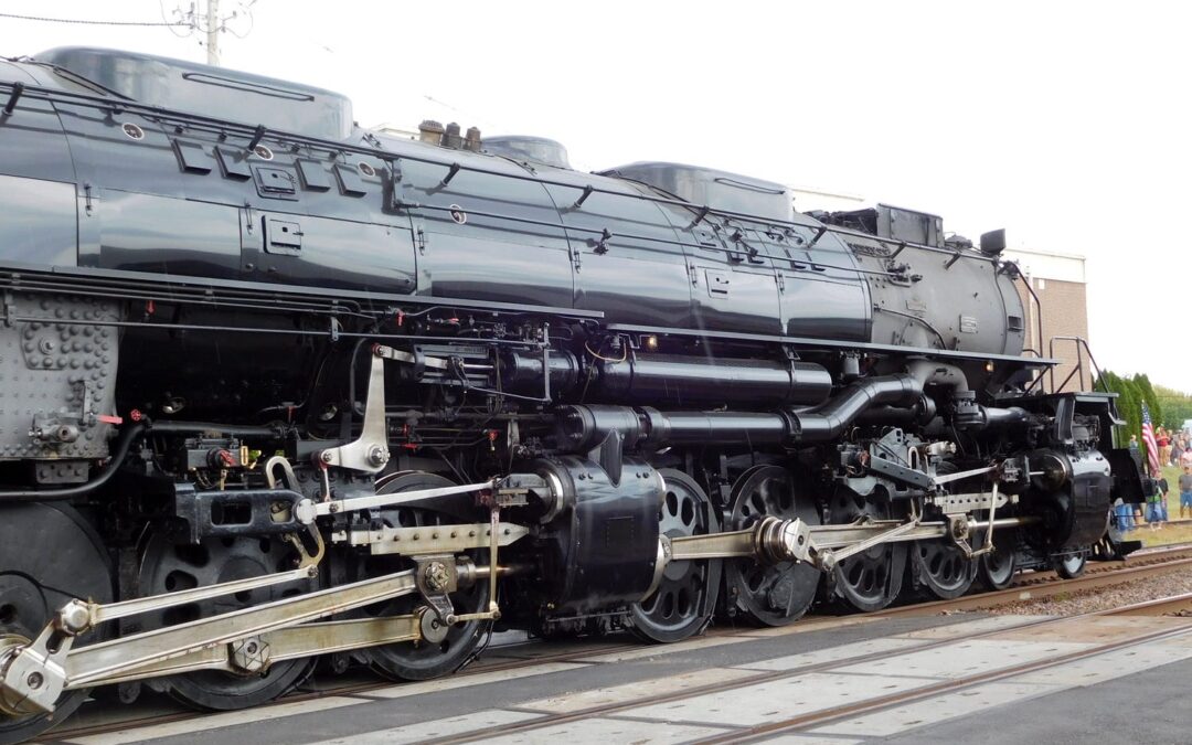
BELLE PLAINE — Little boys love Big Boy. Big boys love Big Boy. On Thursday, hundreds of people turned out to see Big Boy.
“Big Boy” is the nickname of the 25 huge trains built in 1941 for the Union Pacific Railroad. The Omaha World-Herald introduced it as a “mastiff among puny terrier locomotives.” There are seven remaining in museums. That number used to be eight, but No. 4014 was pulled out of a California museum and restored in the 2010s. Five years after its initial excursion in 2019, the last Big Boy returned to Iowa as part of an eight-week, 10-state “Heartland of America Tour.”
John Sutherland, 75, of North Liberty was seeing Big Boy for the first time. “Railroading runs in my family’s blood. My grandfather worked for the Pullman-Standard Steel Car Co. and my great-grandfather was the line superintendent for the Michigan Central Railroad.” He’s not much of a train spotter, but the opportunity to see Big Boy was too good to pass up.
The Iowa-Illinois portion of Big Boy’s 2024 trip followed trackage that was originally part of the Chicago & North Western Railroad and closely parallels U.S. Highway 30 and the Lincoln Highway. Its public stops were in Carroll, Belle Plaine and Grand Mound. Those stops doubled as service periods, since the world’s largest operating steam locomotive requires a high degree of maintenance.
George Kornstead of Iowa City was wearing a Hawkeye Model Railroad Club shirt. He grew up around the rail hub in Duluth and Superior. “Steam is incredible, it really is, to watch how back in the day when people were working on railroad, how hard it was and how intensive it was to keep steam available on the locomotive. Lot of work. The fireman really makes his money.”
The World-Herald in 1941 said at the first Big Boy’s launch, “A single tender loading of coal would heat a six-room home for three years.” This Big Boy has been converted from using coal to using oil.
Steven Ritchie, 6, wore a “Big Boy” T-shirt. His father, Roger, said Steven has seen a lot of train videos and sings “the Big Boy song.” Andrew Schamberger of Hudson wore a C&NW T-shirt. His sister, Becca Scott of West Branch, loves the old steam engines.
According to the UP’s website, No. 4014 racked up a million miles of travel in its 20 years of original service in Wyoming and Utah. It’s nearly twice as long as a standard diesel locomotive and more than half the length of a Boeing 747 jet. The Big Boys “had a 4-8-8-4 wheel arrangement, which meant they had four wheels on the leading set of ‘pilot’ wheels which guided the engine, eight drivers, another set of eight drivers, and four wheels following which supported the rear of the locomotive,” the website says.
The Union Pacific’s “Big Boy” glistens during a light rain shower in downtown Belle Plaine, Iowa, on Thursday, September 5, 2024. Engine No. 4014 was built in 1941, decommissioned in 1961, and restored in time for the 150th anniversary of the transcontinental railroad in 2019. Photo by author.
Big Boy’s visit was a way to connect with railroad history. Paul Duffy, 85, is from “Tama, really,” but now lives nearer Belle Plaine. He worked for the C&NW and then with UP after the two railroads merged. He had been stationed at multiple points along the railroad in Iowa through his career. His oldest of five daughters, Laurie Duffy, remembers going to the station in Tama with her children to wave at Paul as his train went by.
As Big Boy finally pulled into Belle Plaine 55 minutes after its scheduled arrival, the only rain in a week’s worth of weather showed up with it. It did not dampen the spirits of those who waited, although busloads of elementary school students were only able to get a short glimpse of the train before leaving.
On the other track, a modern UP train with a long line of double-stacked shipping containers prepared to resume its trip west. Freight trains have been going through Belle Plaine for more than a century and a half, and Thursday was no exception.
After the wheels had been greased up and spectators got their fill of pictures, Big Boy’s engineer pulled the whistle and rang the bell. The 83-year-old engine began to chug its way toward Cedar Rapids for the night.


")


")


")


")


")


