I’ll take some cover crops with a prairie filter strip on the contour, a side-dressed nitrogen application, a grassed waterway, and riparian buffer strip. Hold the soil, please.
The research that informed Iowa’s Nutrient Reduction Strategy made it clear that there’s a large menu of conservation practices that can keep nutrients and soil on our crop land and out of our waterways. The Agricultural Conservation Planning Framework (ACPF) is one way for farmers to explore those options.
The ACPF toolbox is an add-on for ArcGIS software developed by the USDA Agricultural Research Service. It uses high resolution elevation data along with soils and landuse data to map suitable sites for conservation practices including grassed waterways, saturated buffers, bioreactors, drainage water management, water and sediment control basins, nutrient removal wetlands, and contour buffer strips.
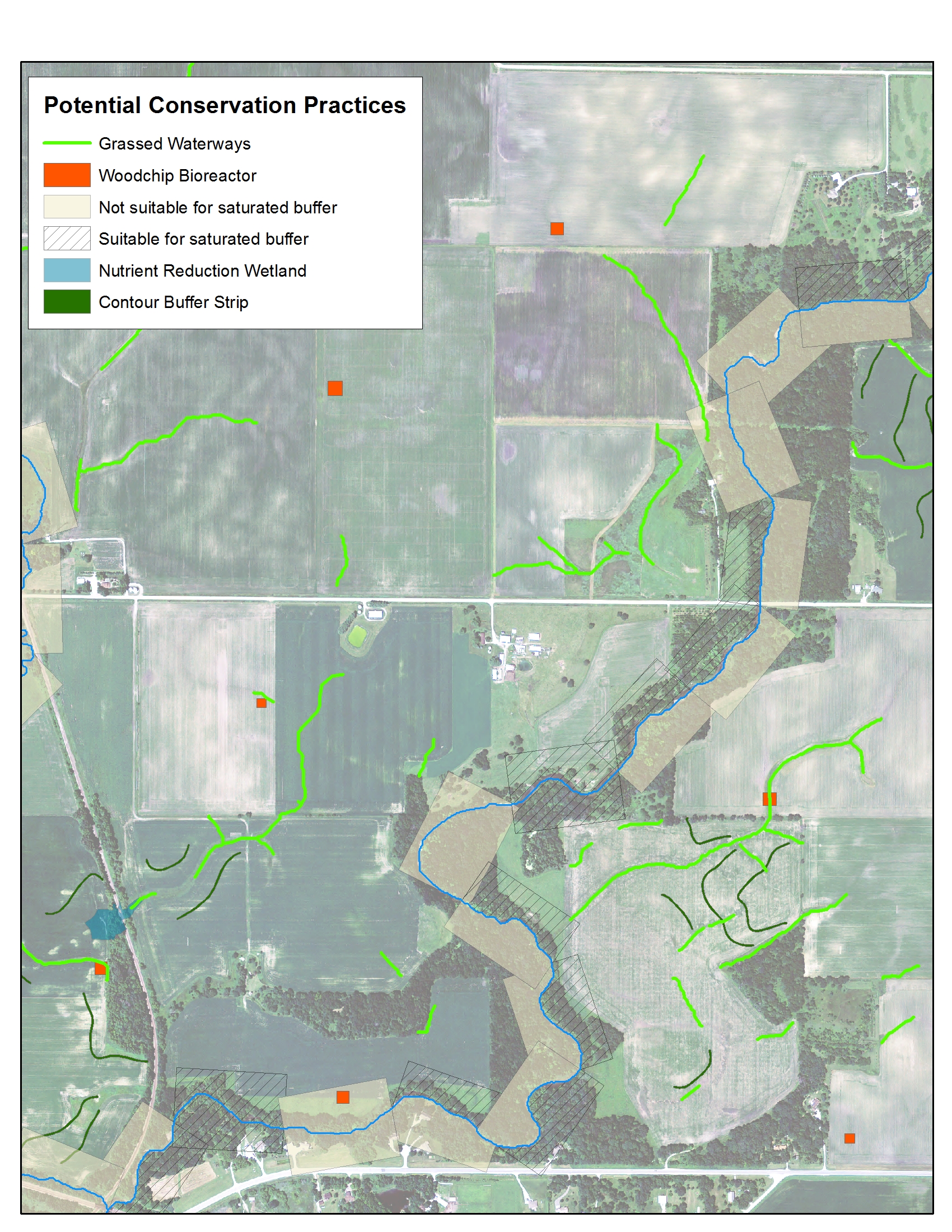
For example, denitrifying bioreactors are a relatively new practice that can prevent excess nitrate in drainage water from reaching streams. A buried bed of woodchips intercepts the flow from tile drains and provides suitable conditions for microbes that can convert the nitrate into nitrogen gas. Bioreactors are designed to treat water from 20-100 acres. The ACPF toolbox analyzes sites at the downstream end of tile-drained fields to find those with 20-100 acres of drainage area upstream, with suitable soils, and with gently sloping terrain.
Prairie Rivers of Iowa is using the ACPF toolbox to identify opportunities for bioreactors in the Squaw Creek watershed so we can let those landowners know about our cost share. When we meet with farmers, we share ACPF maps to reveal other options that might be possible on their land and spark a conversation about what practices make sense for their operation.
On a larger scale, ACPF maps can inform conservation planning for an entire watershed. As part of the Squaw Creek Watershed Management Plan, Emmons & Olivier Resources Inc. (EOR) used an early version of ACPF to determine how many acres of grassed waterways, sedimentation basins, nutrient removal wetlands, and riparian buffers could feasibly be installed in the watershed. This provided an upper limit on the amount of nutrient reduction that might be achieved with these practices, helping us set a realistic plan for implementation. Prairie Rivers and EOR are using ACPF to generate similar maps and analysis for the Keigley-South Skunk watershed, and to support Story County’s countywide assessment of its watersheds.
We’re excited about the potential of this tool and are working on making the results more accessible through web mapping so that you too can “browse the menu” of conservation options.