Dry = Clean? If only
During a long period of dry weather like we’ve been having, some rivers are cleaner than usual, some are just as dirty. It depends on which pollutants we’re talking about, and where they’re coming from. Understanding which is which can help us diagnose problems and prioritize solutions.

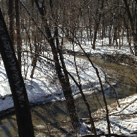
The South Skunk River upstream of Ioway Creek is at its cleanest (clear and with low E. coli) when the weather has been been dry. If you’re going to let your kids splash in the water, go here.

Ioway Creek is less muddy but not any cleaner (high E. coli levels) when the weather has been dry and water levels are low. Lots of algae this summer, too.
For example, if a stream has high E. coli levels when water levels are low, that’s probably not because of manure carried in agricultural runoff… because when the soils are this dry, what little rain we get soaks in and doesn’t run off. Under dry conditions, more likely sources are things like cows in the stream or a septic system illegally hooked up to a drainage tile(yes, we’ve seen this happen). We’ll discuss wastewater treatment plants next time.
The figure below, from the cleanup plan (TMDL) for the Iowa River basin, matches E. coli sources to flow conditions. These kind of graphs take some explanation, but it’s a really helpful framework for making sense of water quality data.

The categories on the x-axis are based on percentiles. “High flows” are the top 10% of daily average flows in a given record. Looking at the last 20 years of data from the USGS gage on the W. Riverside Rd. in Ames (Sleepy Hollow Access), that corresponds to at least 5,453 cubic feet per second of water–probably too fast for safe paddling. “Dry conditions” are the 90th to 60th percentile, corresponding to between 10 and 70 cfs of water–definitely not enough water for paddling.
When graphing stream flow or E. coli, we often use a logarithmic scale, where each major tick mark is a ten-fold increase. Since flow can range from 0 to 10,000 cfs in a river like the South Skunk, it’s the only way you can read it.

Boxplots are helpful for seeing summarizing the data. The bottom, middle line, and top of the box represent the 25th, 50th, and 75th percentiles.
In the upper stretch of the South Skunk River, measured at Sleepy Hollow Access, if you take your canoe out during mid-range conditions, it’s more likely than not that E. coli will meet the primary contact recreation standard (the center line on the box, the median, is below the orange line). It’s even cleaner in dry conditions. Paddlers would benefit from attention to E. coli sources that show up under “wet conditions” such as manure carried in agricultural runoff.

In Ioway Creek at Lincoln Way, E. coli is likely to exceed the secondary contact standard under mid-range conditions, and it’s usually exceeds the primary contact standard across all conditions. Kids play in this creek, and they would benefit from some attention to sources of bacteria that show up under “dry conditions”: this could include inspecting septic systems and working with cattle producers to fence cows out of streams.