1919 Trans-Continental Motor Convoy – 100 Years Later

1919 Trans-Continental Motor Convoy – 100 Years Later

One hundred years ago, in what began as the idea of one man, America was shown how motor trucks could transport troops, supplies, arms, and ammunition across the nation. This was known in 1919 as the First Trans-Continental Motor Transport Convoy.

The Idea and Development 

Henry Ostermann, who we talked about in a previous writing, had been piloting convoys for the Army up and down the east coast in the winter of 1917, during World War I. He was also serving as Field Secretary for the Lincoln Highway Association and merged his two occupations into one idea for the convoy.

In “A Picture of Progress on the Lincoln Way”, published by The Lincoln Highway Association (LHA) in 1920, the LHA  officers and the General Staff in Washington held a conference in June 1919 to discuss convoy details. The success of the run was due to the LHA supplying accurate data to the Army as a “result of its years of study of trans-continental  highway conditions, and of the co-operation given to the Motor Transport Corps, not only by the Headquarters of the Lincoln Highway Association, but by the consular representatives all along the line between the two coasts. The spirit with which the undertaking was met by the general public and the highway officials at every point along the route, was also invaluable to the project.”

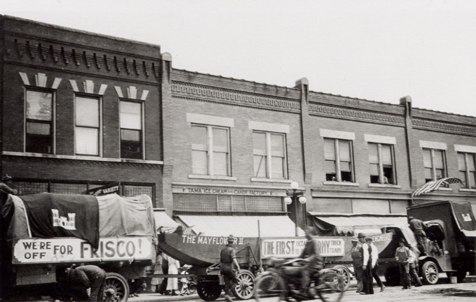
The 1919 Army Convoy taking a break in Tama, Iowa. LHA Archive, Transportation History Collection, Special Collections, University of Michigan

The Route and Key Personnel 

On July 7, 1919, send-off ceremonies were attended by high ranking United States officials, including Secretary of War Baker; General Marsh, Chief of Staff; and many leading U.S. Senators and Representative. At the conclusion of the celebration, the convoy left from “Zero Milestone” near the south lawn of the White House in Washington, D.C..  A marker stands there yet today to commemorate this historic adventure undertaken by the Army. The convoy left from Washington and caught the Lincoln Highway at Gettysburg, Pennsylvania. (The Lincoln Highway actually begins in Times Square in New York.)

From the LHA, “The convoy, consisting of 72 vehicles, 65 of which were motor trucks of all types used by the Government during the war, with a personnel of 260 men and 35 officers as statisticians and observers for the various branches of service, under the command of Lt. Col. Charles B. McClure and Capt. Bernard McMahan, and led by Field Secretary and Vice-President H.C. Ostermann of the LHA, in the Association’s Packard, traversed the continent, covering a distance of 3310 miles from Washington to San Francisco, in sixty-two days, arriving only four days behind the schedule laid out in Washington before the start.”

A young Lt.Col. Dwight Eisenhower was one of the men on this trip. He caught up with the convoy at the first overnight location in Frederick. Maryland. He wrote about his experience and his report is on file at his Presidential Library and Museum in Abilene, Kansas.  https://www.eisenhower.archives.gov.  

Washing dust from a 1919 Army Convoy vehicle in Cedar Rapids. LHA Archives, Transportation History Collection, Special Collections Library, University of Michigan

What the Convoy Taught Us

Eisenhower found most of the drivers in need of additional training and, as with the rest of the convoy leaders, felt the nation’s roads to be lacking. In the Eastern United States, they were often paved but sometimes too narrow for the large equipment. West of Chicago, roads became graveled. Iowa was lucky because it had not rained which would have turned the unpaved road to “gumbo.” The “Seedling Mile,” a one mile of paved road in Linn County near Cedar Rapids, Marion, and Mount Vernon, was completed just prior to the Convoy. The group did not write about it much. As it was, the ground in Iowa was very dry and the convoy, according to the State Center Enterprise, stretched out for as much as 10 miles. Vehicles were kicking up quite a bit of dust and hindering the men and trucks following them. Nearly one hundred bridges were broken and repaired across the nation, though we have no record of any in Iowa. (Iowa was a leader in bridge building.)

This experience showed that America needed to improve roads and the federal government needed to step in with funding instead of leaving it to the locals and counties to build their own roads. How county secondary road departments, county engineers, Federal Highway Commission, and the Department of Transportation developed is a story all its own- which we will address in a later writing.

1919 Motor Convoy crossing the Lincoln Highway Bridge in Tama, Iowa. LHA Archives, Transportation History Collection, Special Collections Library, University of Michigan

What could have happened in Iowa if it had rained! LHA Archives, Transportation History Collection, Special Collections Library, University of Michigan


Celebrating the Convoy 100 Years Later

This one idea from one man helped change the course of transportation. This year, in 2019, we will celebrate the convoy as the Military Vehicle Preservation Association (MVPA) travels the same route, from Washington, D.C. to San Francisco, and will overnight in Iowa- DeWitt (Aug 22), Marshalltown (Aug 23), and Denison (Aug 24). The MVPA call their convoy the “longest Veteran’s parade in the nation.”

The Lincoln Highway Association will also celebrate with their own D.C.-to-San Francisco convoy and overnight in Marshalltown (Sept 6) and Council Bluffs (Sept 7). Be sure to line the route and wave either flags or hands (or both) to the convoys as they come through your neck of the woods.

Corridor Management Plan Update

The Lincoln Highway Heritage Byway is a little over halfway through our 3-year process to create a new Corridor Management Plan for the Byway. The Byway travels through 13 counties and 43 communities in the central part of Iowa. By holding community input meetings in each county, we have included residents in this process. We have asked them to consider the 6 intrinsic qualities that make a Byway: historical, cultural, natural, scenic, recreational, and archaeological. What did they have in their community, what do they currently have in their community and what do they wish to see in their community in relation to these qualities?

Historical is the most prominent quality of the Lincoln Highway. In Iowa, the train came through first and the Lincoln Highway followed the rail line going east and west across the state. They had already found, through trial and tribulations, the driest and flattest areas to lay their tracks and the best places build bridges to cross rivers and streams. Iowa was known for its MUD and the road we take for granted now, did not exist. Road improvements took some time and many conversations were held as to who should maintain and eventually pave main roads. Some felt it was a local responsibility, some felt it was a county’s, and some felt it should be the state’s. Today we see all of these variations depending on what type of road it has become. (Some “loops” of the original route are still gravel!) The Lincoln Highway, itself, is historical, but so are some of the bridges and buildings along the route in the counties the Highway travels through.

Iowans are people from many different cultures. The Meskwaki Nation settled in Iowa after the Louisiana Purchase opened up the territory. Other settlers moved westward and whole towns could be made up of German, Norwegian or Czech immigrants- just to name a few. All along the Byway, each town holds some kind of a summer celebration and offers up their special local foods and shares their customs and uniqueness with visitors.

Some might say Iowa is not that scenic or have many natural features, but just travel the Lincoln Highway and see the changes in the landscape! The Lincoln Highway crosses two major rivers – the Mississippi and Missouri, and other larger rivers- the Cedar, Iowa, Des Moines, and Boyer and  some smaller rivers and streams- the Wapsipinicon, Skunk, North Raccoon, Squaw Creek and Indian Creek, to name a few. Iowa might not have mountains, but the Loess Hills along the Missouri River or the Bohemian Alps, as the locals call them, to the east of Tama, sure show Iowa’s change in elevation. The M and M Divide outside of Carroll has rivers to the east traveling southeast to eventually flow into the the Mississippi and the rivers to the west, traveling southwest flowing into the Missouri River.

Along these rivers, streams, hills, wetlands, prairie potholes, and restored prairies there is a wide variety of recreational opportunities. Visitors and residents can bird watch, canoe, water ski, downhill ski, ice fish, hike, and hunting and fish. There are bike trails, horse trails, off-road vehicle trails, and walking trails.

The State Office of Archaeology has been a great resource for important digs along the Byway. Most sites are kept confidential, but much of Iowa has documented evidence that cultures living here long ago left proof of their existence. As new roads are built and riverbanks are cut away due to flooding and flow of water, new artifacts are bound to be uncovered.

Using all of the information collected in the community meetings and from other sources, we will develop a plan to preserve, restore, and create new opportunities for the communities along the Byway to develop and grow.  At its inception from Times Square to San Francisco, the Lincoln Highway was a way for “common” folks to purchase a car and travel from town to town, county to county, state to state, and see America. The traveler needed to find amenities in each community whether it be a gas station, car repair shop, restaurant, hotel/motel, or campground. This brought economic development to these communities and it was a great honor to be named as a town along the route. Over time, perhaps a newer bridge was built or a road was improved and that caused the route to be moved slightly and those have been developed into “loops”. But for the most part, the route has stayed within the original communities on the proclamation route. How can we measure the impact the Byway has on these 43 communities?

One way is through the Economic Impact study we are conducting as a baseline to determine what impact the Byway has on its Corridor today. Visitor surveys are in 11 locations along the Byway: Sawmill Museum in Clinton, Lincoln Cafe and Wine Bar in Mount Vernon, Belle Plaine Museum in Belle Plaine, King Tower in Tama, John Ernest Vineyard and Winery outside of Tama, Reed- Niland Cafe in Colo, Greene County LHA Museum in Grand Junction, Mahanay Bell Tower in Jefferson, Cronk’s in Denison, Harrison County Welcome Center in Missouri Valley, and the Union Pacific Museum in Council Bluffs. If you are out traveling along the Byway and are 25 miles from your residence, stop into one of these locations and fill out a survey.

The plan is to gather this information and develop it into a working document next year. In the meantime, we welcome comments, concerns, or general stories you might have about the Lincoln Highway Heritage Byway. Comment on this blog or contact Jan Gammon, Lincoln Highway Heritage Byway coordinator, at jgammon@prrcd.org.