by Janice Gammon | May 23, 2019
One hundred years ago, in what began as the idea of one man, America was shown how motor trucks could transport troops, supplies, arms, and ammunition across the nation. This was known in 1919 as the First Trans-Continental Motor Transport Convoy.
The Idea and Development
Henry Ostermann, who we talked about in a previous writing, had been piloting convoys for the Army up and down the east coast in the winter of 1917, during World War I. He was also serving as Field Secretary for the Lincoln Highway Association and merged his two occupations into one idea for the convoy.
In “A Picture of Progress on the Lincoln Way”, published by The Lincoln Highway Association (LHA) in 1920, the LHA officers and the General Staff in Washington held a conference in June 1919 to discuss convoy details. The success of the run was due to the LHA supplying accurate data to the Army as a “result of its years of study of trans-continental highway conditions, and of the co-operation given to the Motor Transport Corps, not only by the Headquarters of the Lincoln Highway Association, but by the consular representatives all along the line between the two coasts. The spirit with which the undertaking was met by the general public and the highway officials at every point along the route, was also invaluable to the project.”

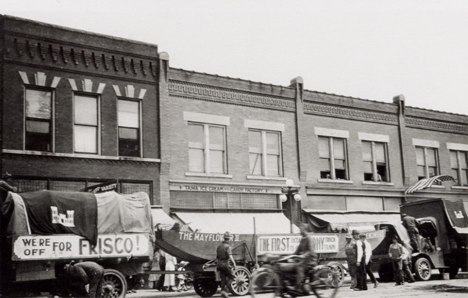
The 1919 Army Convoy taking a break in Tama, Iowa. LHA Archive, Transportation History Collection, Special Collections, University of Michigan
The Route and Key Personnel
On July 7, 1919, send-off ceremonies were attended by high ranking United States officials, including Secretary of War Baker; General Marsh, Chief of Staff; and many leading U.S. Senators and Representative. At the conclusion of the celebration, the convoy left from “Zero Milestone” near the south lawn of the White House in Washington, D.C.. A marker stands there yet today to commemorate this historic adventure undertaken by the Army. The convoy left from Washington and caught the Lincoln Highway at Gettysburg, Pennsylvania. (The Lincoln Highway actually begins in Times Square in New York.)
From the LHA, “The convoy, consisting of 72 vehicles, 65 of which were motor trucks of all types used by the Government during the war, with a personnel of 260 men and 35 officers as statisticians and observers for the various branches of service, under the command of Lt. Col. Charles B. McClure and Capt. Bernard McMahan, and led by Field Secretary and Vice-President H.C. Ostermann of the LHA, in the Association’s Packard, traversed the continent, covering a distance of 3310 miles from Washington to San Francisco, in sixty-two days, arriving only four days behind the schedule laid out in Washington before the start.”
A young Lt.Col. Dwight Eisenhower was one of the men on this trip. He caught up with the convoy at the first overnight location in Frederick. Maryland. He wrote about his experience and his report is on file at his Presidential Library and Museum in Abilene, Kansas. https://www.eisenhower.archives.gov.

Washing dust from a 1919 Army Convoy vehicle in Cedar Rapids. LHA Archives, Transportation History Collection, Special Collections Library, University of Michigan
What the Convoy Taught Us
Eisenhower found most of the drivers in need of additional training and, as with the rest of the convoy leaders, felt the nation’s roads to be lacking. In the Eastern United States, they were often paved but sometimes too narrow for the large equipment. West of Chicago, roads became graveled. Iowa was lucky because it had not rained which would have turned the unpaved road to “gumbo.” The “Seedling Mile,” a one mile of paved road in Linn County near Cedar Rapids, Marion, and Mount Vernon, was completed just prior to the Convoy. The group did not write about it much. As it was, the ground in Iowa was very dry and the convoy, according to the State Center Enterprise, stretched out for as much as 10 miles. Vehicles were kicking up quite a bit of dust and hindering the men and trucks following them. Nearly one hundred bridges were broken and repaired across the nation, though we have no record of any in Iowa. (Iowa was a leader in bridge building.)
This experience showed that America needed to improve roads and the federal government needed to step in with funding instead of leaving it to the locals and counties to build their own roads. How county secondary road departments, county engineers, Federal Highway Commission, and the Department of Transportation developed is a story all its own- which we will address in a later writing.

1919 Motor Convoy crossing the Lincoln Highway Bridge in Tama, Iowa. LHA Archives, Transportation History Collection, Special Collections Library, University of Michigan

What could have happened in Iowa if it had rained! LHA Archives, Transportation History Collection, Special Collections Library, University of Michigan
Celebrating the Convoy 100 Years Later
This one idea from one man helped change the course of transportation. This year, in 2019, we will celebrate the convoy as the Military Vehicle Preservation Association (MVPA) travels the same route, from Washington, D.C. to San Francisco, and will overnight in Iowa- DeWitt (Aug 22), Marshalltown (Aug 23), and Denison (Aug 24). The MVPA call their convoy the “longest Veteran’s parade in the nation.”
The Lincoln Highway Association will also celebrate with their own D.C.-to-San Francisco convoy and overnight in Marshalltown (Sept 6) and Council Bluffs (Sept 7). Be sure to line the route and wave either flags or hands (or both) to the convoys as they come through your neck of the woods.
by Janice Gammon | Jan 29, 2016
The Corridor Management Plan is coming along nicely. From our community input meetings, reviewing city comprehensive plans, and discussions with officials in communities and counties along the Byway we certainly have an exhaustive amount of information and ideas to make a very detailed living document.
I have kept my nose to the grindstone for a while now and did come up for air last week when I took a few days off. The second day back, I attended the Travel Federation of Iowa’s Legislative Showcase at the State Fairgrounds. This was the first event I attended last year when I began as the coordinator of the Lincoln Highway Heritage Byway. I know SO much more about the Lincoln Highway and Byways in general than I did last year at this time. I was able to talk about the Lincoln Highway and the Iowa Byway program to the legislators as they passed by the Iowa Byways’ booth and encouraged them to continue their support of tourism.
This event is also a great way to network with chambers and attractions along the Byway. I chatted with Alan from the Boone and Scenic Valley Railroad, Mark from Council Bluffs Convention and Visitors Center, Taylor from the Cedar Rapids Area Convention and Visitors Bureau and many others. I also had a chance to talk with my fellow Byway coordinators about projects, successes, and challenges.
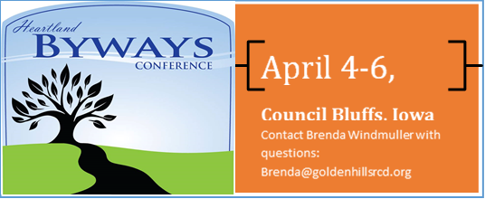
An upcoming event will be hosted by the Iowa Byways. The Heartland Byway Conference will be April 4th-6th in Council Bluffs and we are very excited to have attendees learn more about Western Iowa including the Loess Hills Scenic Byway, Western Skies Scenic Byway, and the Lincoln Highway Heritage Scenic Byway. These three Byways intersect and conjoin for a bit at the Harrison County Historical Village and Welcome Center in Missouri Valley, just north of Council Bluffs. One afternoon, we will take a tour of the Loess Hills and this will be one of the stops.
Key note speakers at the conference will be Michelle Matt, Chuck Offenburger, and the Path Less Peddled. Breakout sessions will include topics such as working with volunteers, GIS, interpretive plans, marketing, infrastructure, corridor management planning, team work, and creating an authentic experience. Anyone interested in Byways and tourism or involved with chambers, visitor bureaus, or serves on an advisory board or volunteers at an attraction is welcome to attend.
I am so excited to be a part of this event! Besides increasing my knowledge and networking with fellow professionals, there will be great food and that bus trip through the Loess Hills! I am looking forward to spending time on this side of the Lincoln Highway Heritage Byway and experience the Loess Hills, Hitchcock Nature Center, and the communities along the route. I am also excited to reconnect with the other Lincoln Highway Byway coordinators from Indiana, Ohio, and Nebraska. We met at the National Scenic Byway training last summer in Ohio and made plans to meet again in Council Bluffs!
If you want to attend, please register at www.brownpapertickets.com. The conference will be held at the Holiday Inn & Suites, 2202 River Road in Council Bluffs. I will tell you all about it in future posts. Be sure to check our Facebook page for photos!
by Janice Gammon | Aug 17, 2015
Summer has been a busy time along the Byway! I did make it to the Mahanay Bell Tower Festival in Jefferson and rode the elevator 120 feet up to the observation deck of the 14-story Tower. What a view!! It gave me a whole new perspective of the countryside and it was great to see the Lincoln Highway as a ribbon running through it. I also enjoyed the beautiful Thomas Jefferson Gardens and RVP~1875, where they make furniture with only hand tools. Its like stepping back in time and they’ll even show you what they are working on!
Another great tour is the Sawmill Museum in Clinton in the Lyons District on the north side of the city. Lyons was the name of the town where the first bridge linked Illinois to Iowa on the Lincoln Highway. Lyons is now part of Clinton. The Sawmill Museum has great displays of the history of the lumber industry in Clinton. It was a “must see” for me and I recommend it for all ages.
The annual Lincoln Highway Association conference was held in Ann Arbor, MI this year. Participants could tour downtown Detroit, the Packard proving grounds, and the archives at the Bentley and Hatcher Libraries at the University of Michigan. Detroit is not on the Lincoln Highway, but has deep connections to the auto industry and to the men who organized the Lincoln Highway and its route.
Another event, although held in Ankeny, did bring a focus to the the Lincoln Highway Heritage Byway when the Harley Owners Group (H.O.G.) Rally had, among many rides, a featured ride to Marshalltown and then to Ames via the Byway. Prairie Rivers of Iowa set up a booth at the H.O.G. Rally and gave out information about the Lincoln Highway Heritage Byway and the Byway program in Iowa. Motorcyclists are very interested in the 2-lane scenic views as their ride (journey) itself is often more important than the destination.
The most recent event I attended was the 101st Meskwaki PowWow held just outside of Tama. I enjoyed the music and dancing, native items for sale, and food vendors. I especially liked the Indian fry bread. Next time I’ll try it as an Indian Taco. Although they invited the spectators to come join in the last dance, I did not. I’ll do that next time as well! Pacing myself.
I am able to travel the state along the Byway and learn more about the communities and their history, strengths, challenges, and plans for the future. We continued the Corridor Management Plan community input meetings,having now held 15 of them across the state. By meeting many of the community leaders and members in each town, we have been able to gather insight into what the Lincoln Highway has done for their community and what it can do for them in the future.
Many communities and counties are working on future ideas as well such as the Story County Cornerstone to Capstone (C2C) project and the plans for the Nevada downtown streetscape. The Boone Historical Museums are partnering with the University of Iowa in developing their 4 museums. I have been working with residents and government officials concerning bridges in the city of Tama and in Linn County. A new Grant Wood mural has been painted on the side of a building in eastern Iowa. The overpass outside of Grand Junction will be replaced in the next few years. There are so many more projects and Ideas in different phases along the Lincoln Highway. It will be exciting to see them all come to fruition!
We are working on a baseline measurement of the economic impact of the Byway. If you are traveling the Lincoln Highway, please stop in one of these locations and fill out a survey about your trip: Sawmill Museum in Clinton, the Belle Plain Museum in Belle Plaine, Lincoln Cafe and Wine Bar in Mt Vernon, John Ernest Vineyard and Winery outside Tama, King Tower restaurant in Tama, Niland Cafe in Colo, Greene County Museum in Grand Junction, Mahanay Bell Tower in Jefferson, Cronk’s restaurant in Denison, the Harrison County Historical Village and Iowa Welcome Center in Missouri Valley, and the Union Pacific Railroad Museum in Council Bluffs.
There will also be a survey for residents to fill out and we should be rolling that out this fall, so stay tuned.
In the meantime, let’s get traveling the Lincoln Highway Heritage Byway!
by Janice Gammon | Apr 20, 2015

John M. presenting in Grand Junction.
This spring, the Lincoln Highway Heritage Byway’s Corridor Management Planning process moves forward into the Lincoln Highway’s many communities. We are holding a series of public meetings to introduce the Lincoln Highway Heritage Byway, and the concept of a Corridor Management Plan, to residents around the state.
You may recall that a Corridor Management Plan (CMP) is a written document setting out a long-term plan for a byway and its important resources. The Lincoln Highway Heritage Byway’s original CMP was created before the Lincoln Highway was designated as an Iowa Byway, so it no longer reflects needs of Lincoln Highway communities and residents. The new revision of the CMP will reflect the Lincoln Highway Heritage Byway as an active and thriving part of Iowa’s past and present heritage.
Upcoming public meetings are April 22 in Ames, April 23 in Toledo, April 25 in Marion, April 27 in Missouri Valley and Denison, April 28 in Carroll, and May 5 in Nevada. Please visit www.prrcd.org/cmp to find out details about the meeting time and location in your area.

State Center CMP meeting.
Previous meetings have already been held in State Center, Jefferson, Lowden, and Clinton. Local residents, Lincoln Highway Association members, elected officials, business owners, and others came out to share their ideas on the Lincoln Highway’s important assets and their dreams for what the Lincoln Highway could be in the future. Each meeting featured great discussions and we are very appreciative for the time and energy of all attendees. We will be taking all these ideas and developing priorities for the whole byway and for future activities in each community.
As always, to stay informed about the latest CMP activities in your community, sign up for our email list (visit www.prrcd.org/cmp and click the blue “sign up” button), email me at lincolncmp@prrcd.org, or call me at 515-216-4005. Looking forward to seeing you at a community meeting soon!
by Janice Gammon | Apr 17, 2015
 The Iowa League of RC&DS received a Conservation Innovation Grant (CIG) and a REAP Conservation Education Grant to create two interpretive panels for each Iowa Byway describing an employed conservation method. “The CIG program is a voluntary program intended to stimulate the development and adoption of innovative conservation approaches and technologies while leveraging Federal investment in environmental enhancement and protection, in conjunction with agricultural production”, according to the program’s website. “CIG enables the Natural Resources Conservation Service to work with other public and private entities to accelerate technology transfer and adoption of promising technologies and approaches to address some of the Nation’s most pressing natural resource concerns.”
Some of the sites that were considered for these interpretive panels along the Lincoln Highway Heritage Byway were bogs, wetlands, prairies, and high tunnel towers. The location needed to be where travelers could pull safely off the road and visibly see the sign. It needed to be on or near a conservation practice site.
The two site selected along the Lincoln Highway Heritage Byway were the Lincoln Prairie Park in Ogden and the West Beaver Creek, outside of Grand Junction, at the Lion’s Tree Park. The sign In Ogden educates the reader about the functions of a prairie and the importance of prairie plant root systems in filtering water. The sign at West Beaver Creek describes the effects buffers have on streams and the natural and man-made drains used to move water across (and under) the rolling landscape.
 Both signs were tied to the Lincoln Highway Heritage Byway through the use of the Byway logo, photo of a Lincoln Highway concrete marker at the Lincoln Prairie Park, and a photo of the many generations of bridges located near the Lion’s Tree Park outside of Grand Junction.
Signs will soon be in the fabrication phase and installed mid-to-late summer. The panels will be installed on a weathered steel base with cutouts of prairie grass or wild flowers. This is in keeping with the Interpretive Plan design created by Schmeekle Reserve from Stephens Point, Wi. The company is creating an Interpretive Plan for each byway.
An event will be held at each location after installation and we will unveil the signs. Thanks to Kevin Griggs for writing the text and Jessica Johnson for her design work on the panels.


